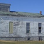
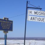
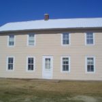
There are places you hit the brakes. It can be a view but more often than not it is the question of what the heck was going on here. As you can see from these pictures, there are three great stone houses in a row on a rather quite back country road in Lewis County New York. The afternoon shadow across their fronts confirm their eastern orientation facing across the valley. But why, away from a river where mills could develop, did this small hamlet have such a grand life almost 200 years ago. The sign next to the pink sided Freedom Wright’s Inn gives some indication of the importance of the place at one time, as does the solid but closed up church.


The first occupation by Europeans of the area comes relatively late or so sayeth the 1927 The History of New York State (pub., Lewis Historical Publishing Company, Inc.):
The settlement of the northern section of New York was greatly delayed by the ignorance concerning it. Old maps of the section named it Irocoicia. “The Land of the Iroquois,” or Coughsagraga, “The Dismal Wilderness.” Travelers who skirted the edges said it was a region of swamps and mountain barrens. Sauthier’s map, published in England in 1777 and supposed to be the beat and latest in its information, mentions it as “This marshy tract is full of beavers and otters.” There is no map earlier than 1795 that shows a trace of the Black River. Soldiers, possibly those of Sullivan’s expedition, knew something of the territory. But it is in no way surprising that when offers were made to the land commissioners of New York for these supposed waste barrens, that they should be accepted readily, and the land sold for mere pittances and on the easiest of terms. One of the many sales, and the, was that to Macomb. On June 22, 1791, Alexander Macomb made an offer for certain lands, the payment to be one-sixth part of the purchase price yearly until the account was complete, no interest to be charged. The price offered was eight pence an acre. Macomb secured net 3,670,715 acres, divided into six great tracts. The one numbered four included the larger part of the counties of Jefferson and Lewis. Macomb conveyed this tract, with others, to William constable, and he in turn part to others sop that the deeds to Lewis County are traced back to nine great tracts known as: Black River, Inmans’ Triangle, Constable’s Four Towns, Brantingham, Brown’s, Watson’s, Castorland, and Great Tract Number Four.
Early settlers included Bedells and many others. Denmark was the first township to be constituted in 1807 after the founding of the county two years before. Someone of local legal note – who attened Denmark Academy and who studied law… in Lowville – was born there in 1825 as was an Iowa banker in 1833 as well as a Mayor of Ottawa. It wasn’t until about 40 years after its founding that the now larger towns formed in the valley below:
In 1848, the towns of Croghan and New Bremen were formed by French, German, and Swiss immigrants.
These towns were likely created as part of the development of the Black River canal, an unprofitable spur off the Erie, which opened in 1855. Denmark was on one branch of the underground railroad, moving slaves from the US south to Canada. A golf club formed in 1925.


 But I did not stop there. I recall a reference or two to
 I also bought The Beginning Stage of…The Polyphonic Spree, the Jesus Freaks meets Supertramp and small college revival of the musical Godspell as it might have been presented by and only to the members of some lesser 1970s Christian cult, one that never got to the purple Kool-aid.


