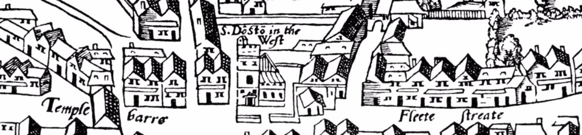
What a charming image. It is a tiny bit of a map of Portsmouth, England from 1552. These four structures are The Dragon, The Lyon, The White Hart and The Rose – the four brewhouses built in 1515 by Henry VIII that I mentioned in my blog post on my first scratching about (what I should have called) Tudor brewing and Tudor naval victualing from earlier this month. There is much written* about Portsmouth, the Tudors and navel power but I am thinking about only one corner of it all. That being the corner in the image above. and these four brew houses. They are consistently illustrated throughout the 1500s as this passage from an academic article by one Dominic Fontana describes:
The four brewhouses are labelled on the 1584 map with their names; The Dragon, The Lyon, The White Hart and The Rose, and are clearly shown as being located around a pond, probably a freshwater spring providing the significant quantities of water essential for brewing. The four brewhouses were established in 1515 by Henry VIII to provide beer for his ships. They produced considerable quantities, making 500 barrels per day in 1515 (Eley 1988). Provisioning of Henry’s fleet and shore forts was an enormous task requiring significant organisation and by 1547 naval victualling was regularly accounted to the Exchequer (Knighton and Loades 2014). The engraving shows the brewhouses as timber framed buildings located almost as though they were mounted on stilts above a pond which extends underneath and around the buildings. Evidence for the brewhouses is also provided in the maps of 1545 and 1552. In the 1545 map they are shown as four rectangular buildings with a small square extension added to one side of each building, with the four brewhouses being grouped around a square pond. In the 1552 map the buildings are presented in bird’s-eye view as a group of low buildings with pitched roofs set around an irregularly shaped pond.**
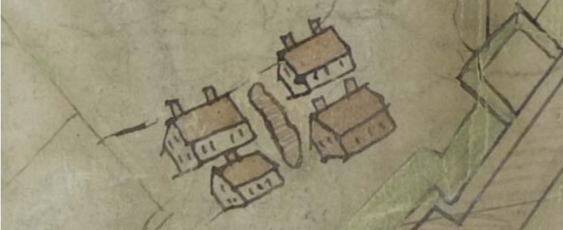
 The 1545 map of Portsmouth mentioned above illustrates the same brewhouses with a little less of a lyrical touch but perhaps more to scale. The red arrow is mine, in case you were wondering. This handy tool allows an overlay of the 1545 upon a map showing Portsmouth today. So regularly they sit. Clearly a work of joint undertaking. One thing I notice is how four regular standardized breweries would have had more fire resistance that one single larger brewery. They are spaced as well. Embers from one might not reach the roof of another.
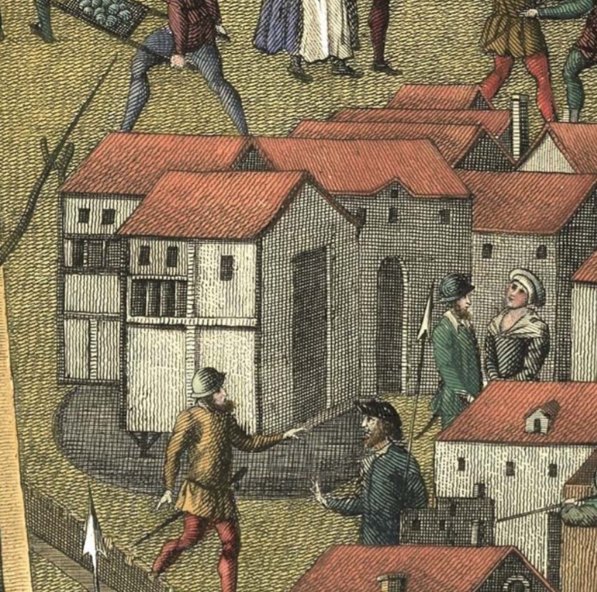 There is another image, the Cowdray Engraving which is a copy of painting from between 1545-1548 depicting the Battle of the Solent and the sinking of the Mary Rose. Almost a pictograph. Whatever a pictograph is. The relevant wee snippet of the 1545 map-like diagram*** can be viewed with the merest click on the thumbnail to the right. As you can see, it is more than a map in that there are all sorts of folk well out of scale because it is not really about the mapping of Portsmouth but a description of the naval battle that was occurring right outside the mouth of the harbour. Again, it gives a sense of uniformity but also notice they seem to be on stilts and over the pond in this image. That would not jive with the two maps.
The pond itself was described in a modern footnote to an edict issued by Elizabeth I on 7 December 1562 included in the Extracts from Records in the Possession of the Municipal Corporation of the Borough of Portsmouth and from Other Documents Relating Thereto:
These springs of remarkably fine fresh water from which the inhabitants at this time derived their chief supply, were situated within the ancient walls in a triangular shaped meadow at the upper or eastern end of Penny and St. Nicholas Streets: the meadow was called ” Four House Green,” from its proximity to the Four Houses, which were erected by Henry VII. as Brewing Houses for the supply of his Navy; this site is now occupied by the Clarence Barracks. In the time of Charles the II., when the fortifications were reconstructed, in the star like form as they remained until their recent demolition, Four House Green was absorbed, and the greater part of it excavated to form the moat, and cast ravelin which was opposite to what is now known as King’s Road, Southsea. The springs were then enclosed in stone cisterns, which were approached by a postern through the rampart, and an iron bridge across the moat, and were used by some of the older inhabitants until a recent period.
So the site was restructured to the point no archaeology can be expected. Hmm. Notice up there the statement about the scale of production: “[t]hey produced considerable quantities, making 500 barrels per day in 1515 (Eley 1988).” I have not laid my hands upon a copy of Eley 1988 but have identified it as Portsmouth breweries, 1492-1847 by Phillip Eley, published by Portsmouth City Council in, yes, 1988.**** It is comfortingly affirmed by Dr. Fontana but, still, I checked with my man who sits in the same buildings as one of the world’s great libraries, the New York State Library, in Albany but no luck. If you have a copy, let me know. I say this because I find the scale extraordinary. Even on a 200 working day year that is 100,000 bbls a year. Kristen D. Burton in this 2013 article describes the scale of brewing being undertaken in the whole of the City of London during Tudor times:
The beer brewers of London established England’s capital city as the leading producer of beer throughout Europe by the end of the sixteenth century; a notable feat considering the late arrival of hopped beer to England. In 1574, London beer brewers produced 312,000 barrels of beer and by 1585 that had increased to 648,690 barrels. This stood in addition to the beer produced for local consumption, which made up the bulk of the brewers’ business…
I am not suggesting there is anything wrong with these numbers so much as they mean the four naval brewhouses of Portsmouth were operating at a fabulous scale. I even saw one reference that suggested that each produced 500 barrels a day. Now, that would be scale and in the pre-scientific pre-industrial era certainly something that. Within sight of the porter breweries of the 1830s.
Again, I am going to leave this at that for now. I need to scratch around a bit more. Do let me know if you have a copy of that book by Eley under a table leg. I would love to see the primary record behind that number.
*You may wish to start here.
**See: “Charting the Development of Portsmouth Harbour, Dockyard and Town in the Tudor Period” Dominic Fontana, Journal of Maritime Archaeology, Vol. 8, No. 2, Special Issue: The Social Archaeology of Ports and Harbours (DECEMBER 2013), pp. 263-282. Abstract: “Portsmouth was crucial to the defence of Tudor England and consequently it was mapped for military planning purposes throughout the Tudor period from 1545. The resulting sequence of maps records much of the town and harbour. The maps offer opportunities for furthering our understanding of Tudor Portsmouth and its population Additionally, images of the urban landscape provided by the ‘‘Cowdray Engraving’’, which depicts the loss of Henry VIII’s warship Mary Rose on the 19th July 1545, may also be considered and compared with those presented in the early maps of the town. This paper considers the Portsmouth maps of 1545, 1552, 1584 and the chart of Portsmouth Harbour dating from between 1586 and 1620. These are examined in relation to one another and compared with evidence from the Cowdray Engraving.” The author is, in fact, Dr Dominic Fontana, FRGS, of Portsmouth University.
***Most fabulously of all, while the original painting burned in the 1790s, “in the 1770’s the Society of Antiquities became interested in the paintings and commissioned James Basire” to engrave it and make notes on the colours… AND between 1772 and 1778 the same “Basire had a young apprentice who most likely also helped with these engravings, his name was William Blake.” Wow!!! You can play a bit of Where’s Waldo on this bigger snippet.
****ISBN 10: 0901559733
Hi, very late to this party and you may well already have received the info.
Portsmouth Breweries 1492 – 1847 by Philip Eley, Portsmouth Papers 51, pub, March 1988.
p. 4: ‘The brewhouses were at work by June 1513, producing over 500 barrels a day and were the “goodliest” that Lord Howard had ever seen*, but an attempt to brew with malted oats met with customer resistance; the army refused to drink the beer and it did not keep well …’
*A footnote at this point refers to Letter & Papers, Foreign & Domestic, Henry VIII, Vol. 1, No. 1978.
Hope this helps, if indeed you haven’t long since had the info!
Fabulous! Thanks for the information.